May 1, 2014
Meteor Shower Calendar
The meteor showers listed below are the easiest to observe and
provide the most activity. Particular attention should be noted to the
time and moonlight conditions. All these showers are best seen after
midnight. Some are not even visible until after midnight. Showers that
peak with the moon’s phase greater than one half illuminated (first
quarter to last quarter) will be affected by moonlight and difficult to
observe. While the time each shower is best seen remains much the same
year after year, the moonlight conditions change considerably from one
year to the next. As we approach the date of each shower's maximum, be
sure to consult the latest AMS article about Meteor Showers, which will provide in depth information on each shower and how to best view it.
 Peak night
 Jan 2-3
Quadrantids Active from January 1st to 10th 2014
The Quadrantids have the potential to be the strongest shower of the year but usually fall short due to the short length of maximum activity (6 hours) and the poor weather experienced during early January. The average hourly rates one can expect under dark skies is 25. These meteors usually lack persistent trains but often produce bright fireballs. Due to the high northerly declination (celestial latitude) these meteors are not well seen from the southern hemisphere.Radiant: 15:18 +49.5° - ZHR: - Velocity: 26 miles/sec (medium - 42.2km/sec) - Parent Object: 2003 EH (Asteroid)
 Peak night
 Apr 21-22
Lyrids Active from April 16th to 25th 2014
The Lyrids are a medium strength shower that usually produces good rates for three nights centered on the maximum. These meteors also usually lack persistent trains but can produce fireballs. These meteors are best seen from the northern hemisphere where the radiant is high in the sky at dawn. Activity from this shower can be seen from the southern hemisphere, but at a lower rate.Radiant: 18:04 +34° - ZHR: - Velocity: 30 miles/sec (medium - 48.4km/sec) - Parent Object: C/1861 G1 (Thatcher)
 Peak night
 May 5-6
Eta Aquariids Active from April 19th to May 26th 2014
The Eta Aquariids are a strong shower when viewed from the southern tropics. From the equator northward, they usually only produce medium rates of 10-30 per hour just before dawn. Activity is good for a week centered the night of maximum activity. These are swift meteors that produce a high percentage of persistent trains, but few fireballs. The Eta Aquariids are a strong shower when viewed from the southern tropics. From the equator northward, they usually only produce medium rates of 10-30 per hour just before dawn. Activity is good for a week centered the night of maximum activity. These are swift meteors that produce a high percentage of persistent trains, but few fireballs.Radiant: 22:32 -1° - ZHR: - Velocity: 42 miles/sec (swift - 66.9km/sec) - Parent Object: 1P/Halley
 Peak night
 Jul 27-28
Delta Aquariids Active from July 21st to August 23rd 2014
The Delta Aquariids are another strong shower best seen from the southern tropics. North of the equator the radiant is located lower in the southern sky and therefore rates are less than seen from further south. These meteors produce good rates for a week centered on the night of maximum. These are usually faint meteors that lack both persistent trains and fireballs.Radiant: 22:40 -16.4° - ZHR: - Velocity: 26 miles/sec (medium - 42km/sec) - Parent Object: 96P/Machholz?
Peak night Jul 28-29
Alpha Capricornids Active from July 11th to August 10th 2014
The Alpha Capricornids are active from July 11 through August with a "plateau-like" maximum centered on July 29. This shower is not very strong and rarely produces in excess of five shower members per hour. What is notable about this shower is the number of bright fireballs produced during its activity period. This shower is seen equally well on either side of the equator.Radiant: 20:28 -10.2° - ZHR: - Velocity: 15 miles/sec (slow - 24km/sec) - Parent Object: 169P/NEAT
 Peak night
 Aug 11-12
Perseids Active from July 13th to August 26th 2014
The Perseids are the most popular meteor shower as they peak on warm August nights as seen from the northern hemisphere. The Perseids are active from July 13 to August 26. They reach a strong maximum on August 12 or 13, depending on the year. Normal rates seen from rural locations range from 50-75 shower members per hour at maximum. Many of thRadiant: 03:12 +57.6° - ZHR: - Velocity: 37 miles/sec (swift - 60km/sec) - Parent Object: 109P/Swift-Tuttle
 Peak night
 Oct 21-22
Orionids Active from October 4th to November 14th 2014
The Orionids are a medium strength shower that sometimes reaches high strength activity. In a normal year the Orionids produce 20-25 shower members at maximum. In exceptional years, such as 2006-2009, the peak rates were on par with the Perseids (50-75 per hour). At this time we are unable to predict exactly when the Orionids will be exceptionRadiant: 06:20 +15.5° - ZHR: - Velocity: 41 miles/sec (swift - 67km/sec) - Parent Object: 1P/Halley
 Peak night
 Oct 8-9
Southern Taurids Active from September 7th to November 19th 2014
The Southern Taurids are a long-lasting shower that reaches a barely noticeable maximum on October 9 or 10. The shower is active for more than two months but rarely produces more than five shower members per hour, even at maximum activity. The Taurids (both branches) are rich in fireballs and are often responsible for increased number of fireball reports from September through November.Radiant: 02:08 +8.7° - ZHR: - Velocity: 17 miles/sec (slow - 28km/sec) - Parent Object: 2P/Encke
 Peak night
 Nov 12-13
Northern Taurids Active from October 19th to December 10th 2014
This shower is much like the Southern Taurids, just active a bit later in the year. When the two showers are active simultaneously in late October and early November, there is sometimes an notable increase in the fireball activity. There seems to be a seven year periodicity with these fireballs. 2008 was the last remarkable year. Perhaps 2015 will be the next?Radiant: 03:52 +22.7° - ZHR: - Velocity: 18 miles/sec (medium - 30km/sec) - Parent Object: 2P/Encke
 Peak night
 Nov 17-18
Leonids Active from November 5th to 30th 2014
The Leonids are best known for producing great meteor storms in the years of 1833, 1866, 1966, and 2001. These outbursts of meteor activity are best seen when the parent object, comet 55P/Tempel-Tuttle, is near perihelion (closest approach to the sun). Yet it is not the fresh material we see from the comet, but rather debris from earlier returns that also happen to be most dense at the same time. Unfortunately it appears that the earth will not encounter any dense clouds of debris until 2099. Therefore when the comet returns in 2031 and 2064, there will be no meteor storms, but perhaps several good displays of Leonid activity when rates are in excess of 100 per hour. The best we can hope for now until the year 2030 is peaks of around 15 shower members per hour and perhaps an occasional weak outburst when the earth passes near a debris trail. The Leonids are often bright meteors with a high percentage of persistent trains.Radiant: 10:08 +21.6° - ZHR: - Velocity: 44 miles/sec (swift - 71km/sec) - Parent Object: 55P/Tempel-Tuttle
Peak night Dec 13-14
Geminids Active from December 4th to 16th 2014
The Geminids are usually the strongest meteor shower of the year and meteor enthusiasts are certain to circle December 13 and 14 on their calendars. This is the one major shower that provides good activity prior to midnight as the constellation of Gemini is well placed from 10pm onward. The Geminids are often bright and intensely colored. Due to their medium-slow velocity, persistent trains are not usually seen. These meteors are also seen in the southern hemisphere, but only during the middle of the night and at a reduced rate.Radiant: 07:28 +32.2° - ZHR: - Velocity: 22 miles/sec (medium - 35km/sec) - Parent Object: 3200 Phaethon (asteroid)
 Peak night
 Dec 21-22
Ursids Active from December 17th to 23rd 2014
The Ursids are often neglected due to the fact it peaks just before Christmas and the rates are much less than the Geminds, which peaks just a week before the Ursids. Observers will normally see 5-10 Ursids per hour during the late morning hours on the date of maximum activity. There have been occasional outbursts when rates have exceeded 25 per hour. These outbursts appear unrelated to the perihelion dates of comet 8P/Tuttle. This shower is strictly a northern hemisphere event as the radiant fails to clear the horizon or does so simultaneously with the start of morning twilight as seen from the southern tropics.Radiant: 14:28 +74.8° - ZHR: - Velocity: 20 miles/sec (medium - 32km/sec) - Parent Object: 8P/Tut
April 15, 2014
Predictions for the eclipses are summarized in Figures
1,
2,
3, and
4.
World maps show the regions of visibility for each eclipse.
The lunar eclipse diagrams also include the path of the Moon through
Earth's shadows.
Contact times for each principal phase are tabulated along with the
magnitudes and geocentric coordinates of the Sun and Moon at greatest
eclipse.
All times and dates used in this publication are in Universal
Time or UT. This astronomically derived time system is
colloquially referred to as Greenwich Mean Time or GMT. To
learn more about UT and how to convert UT to your own local time,
see Time Zones and Universal
Time.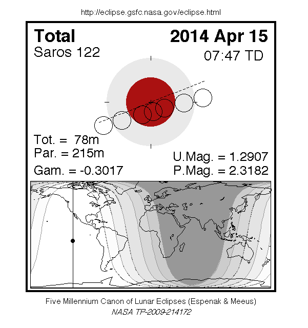
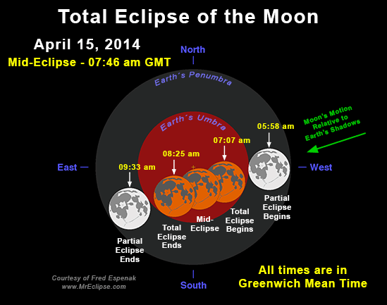
Total Lunar Eclipse of April 15
The first eclipse of the year is well placed for observers throughout
the Western Hemisphere.
The eclipse occurs at the lunar orbit's ascending node in Virgo.
The apparent diameter of the Moon is close to its average since the
eclipse occurs nearly midway between apogee (April 08 at 14:53 UT) and
perigee (April 23 at 00:28 UT).
This is the first of four consecutive total lunar eclipses in 2014 and
2015 (see Lunar Eclipse Tetrads).
The Moon's orbital trajectory takes it through the southern half of Earth's umbral shadow.
Although the eclipse is not central, the total phase still lasts 78 minutes.
The Moon's path through Earth's shadows as well as a map illustrating worldwide visibility of the event are shown in Figure 1.
The times of the major eclipse phases are listed below.
          Penumbral Eclipse Begins:  04:53:37 UT
          Partial Eclipse Begins:    05:58:19 UT
          Total Eclipse Begins:      07:06:47 UT
          Greatest Eclipse:          07:45:40 UT
          Total Eclipse Ends:        08:24:35 UT
          Partial Eclipse Ends:      09:33:04 UT
          Penumbral Eclipse Ends:    10:37:37 UT
At the instant of greatest eclipse[1] (07:45:40 UT) the Moon lies at the zenith for a point in the South Pacific about 3000 km southwest of the Galapagos Islands.
The umbral eclipse magnitude[2]
peaks at 1.2907 as the Moon's northern limb passes 1.7 arc-minutes
south of the shadow's central axis.
In contrast, the Moon's southern limb lies 9.0 arc-minutes from the
southern edge of the umbra and 40.0 arc-minutes from the shadow centre.
Thus, the northern half of the Moon will appear much darker than the
southern half because it lies deeper in the umbra.
Since the Moon samples a large range of umbral depths during totality,
its appearance will change significantly with time.
It is not possible to predict the exact brightness distribution in the
umbra, so observers are encouraged to estimate the Danjon value at
different times during totality (see Danjon Scale of Lunar Eclipse Brightness).
Note that it may also be necessary to assign different Danjon values to
different portions of the Moon (i.e., north verses south).
During totality, the spring constellations are well placed for viewing
so a number of bright stars can be used for magnitude comparisons.
Spica (m = +1.05) is the most conspicuous star lying just 2° west of the
eclipsed Moon.
This juxtaposition reminds the author of the total lunar eclipse of 1968
Apr 13 when Spica appeared only 1.3° southwest of the Moon at
mid-totality.
The brilliant blue color of Spica made for a striking contrast with the
crimson Moon.
Just a week past opposition, Mars (m = -1.4) appears two magnitudes
brighter than Spica and lies 9.5° northwest of the Moon.
Arcturus (m = +0.15) is 32° to the north, Saturn (m = +0.2) is 26° to
the east, and Antares (m = +1.07) is 44° to the southeast.
The entire event is visible from both North and South America.
Observers in the western Pacific miss the first half of the eclipse because it occurs before moonrise.
Likewise most of Europe and Africa experience moonset just as the eclipse begins.
None of the eclipse is visible from north/east Europe, eastern Africa, the Middle East or Central Asia.
Table 1 lists predicted umbral immersion and emersion times for 25 well-defined lunar craters.
The timing of craters is useful in determining the atmospheric enlargement of Earth's shadow (see Crater Timings During Lunar Eclipses).
The April 15 eclipse is the 56th eclipse of Saros[3]
122.
This series began on 1022 August 14 and is composed of 74 lunar eclipses
in the following sequence: 22 penumbral, 8 partial, 28 total, 7
partial, and 9 penumbral eclipses (Espenak and Meeus, 2009).
The last eclipse of the series is on 2338 October 29.
Complete details for Saros 122 can be found at:
For additional diagrams, maps, tables and information on the April 15 total lunar eclipse can be found at:
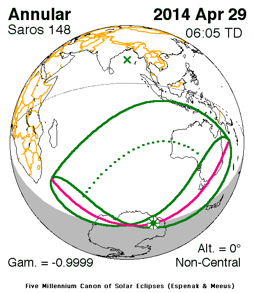
Annular Solar Eclipse of April 29
The first solar eclipse of 2014 occurs at the Moon's descending node in
southern Aries.
This particular eclipse is rather unusual because the central axis of
the Moon's antumbral shadow misses Earth entirely while the shadow edge
grazes the planet.
Classified as a non-central annular eclipse, such events are rare.
Out of the 3,956 annular eclipses occurring during the 5,000-year period
-2000 to +3000, only 68 of them or 1.7% are non-central (Espenak and
Meeus, 2006).
The northern edge of the antumbral shadow first touches down in Antarctica at 05:57:35 UT.
The instant of greatest eclipse[4]
occurs just six minutes later at 06:03:25 UT.
For an observer at the geographic coordinates nearest the shadow axis
(131° 15.6' E, 79° 38.7' S), the Sun would appear on the horizon during
the 49-second annular phase.
Six minutes later (06:09:36 UT), the antumbral shadow lifts off the
surface of Earth as the annular eclipse ends.
The entire zone of annularity appears as a small D-shaped region in
eastern Antarctica (Figure 2).
A partial eclipse is seen within the much broader path of the Moon's
penumbral shadow, that includes the southern Indian Ocean, the southern
edge of Indonesia and all of Australia (Figure 2).
Local circumstances for a number of cities in Australia are found in Table 2.
All times are given in Universal Time.
The Sun's altitude and azimuth, the eclipse magnitude[5] and obscuration[6] are all given at the instant of maximum eclipse.
This is the 21st eclipse of Saros 148 (Espenak and Meeus, 2006).
The family began with a series of 20 partial eclipses starting on 1653
Sep 21.
The 2014 Apr 29 eclipse is actually the first annular eclipse of the
series.
It will be followed by another annular on 2032 May 09.
The series switches to hybrid on 2050 May 20 followed by the first 40
total eclipses on 2068 May 31.
After a final 12 partial eclipses, Saros 148 terminates on 2987 Dec 12.
Complete details for the 75 eclipses in the series (in the sequence of
20 partial, 2 annular, 1 hybrid, 40 total, and 12 partial) may be found
at:
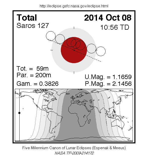
Total Lunar Eclipse of October 08
The second lunar eclipse of 2014 is also total and is best seen from the Pacific Ocean and bordering regions.
The eclipse occurs at the Moon's descending node in southern Pisces, two days after perigee (October 06 at 09:41 UT).
This means that the Moon will appear 5.3% larger than it did during the April 15 eclipse (32.7 vs. 31.3 arc-minutes).
This time the orbital path of the Moon takes it through the northern half of Earth's umbral shadow.
The total phase lasts 59 minutes primarily because the diameter of the umbral shadow is larger (1.49° verses 1.39°).
The lunar path through Earth's shadows as well as a map illustrating worldwide visibility of the event are shown in Figure 3.
The times of the major eclipse phases are listed below.
               Penumbral Eclipse Begins:   08:15:33 UT
               Partial Eclipse Begins:     09:14:48 UT
               Total Eclipse Begins:       10:25:10 UT
               Greatest Eclipse:           10:54:36 UT
               Total Eclipse Ends:         11:24:00 UT
               Partial Eclipse Ends:       12:34:21 UT
               Penumbral Eclipse Ends:     13:33:43 UT
At the instant of greatest eclipse (10:54:36 UT) the Moon lies near the
zenith from a location in the Pacific Ocean about 2000 km southwest of
Hawaii.
At this time, the umbral magnitude peaks at 1.1659 as the Moon's
southern limb passes 6.6 arc-minutes north of the shadow's central axis.
In contrast, the Moon's northern limb lies 5.4 arc-minutes from the
northern edge of the umbra and 39.3 arc-minutes from the shadow centre.
As a result, the southern half of the Moon will appear much darker than
the northern half because it lies deeper in the umbra.
The Moon samples a large range of umbral depths during totality so its
appearance will change considerably with time.
The exact brightness distribution in the umbra is difficult to predict,
so observers are encouraged to estimate the Danjon value at different
times during totality (see Danjon Scale of Lunar Eclipse Brightness).
It may also be necessary to assign different Danjon values to different portions of the Moon (e.g., north vs. south).
During totality, the autumn constellations are well placed for viewing
and the brighter stars can be used for magnitude comparisons.
The center of the Great Square of Pegasus lies 15° to the northwest, its
brightest star being Alpheratz (m = +2.02).
Deneb Kaitos (m = +2.04) in Cetus is 30° south of the eclipsed Moon,
while Hamal (m = +2.01) is 25° to the northeast, Aldebaran (m = +0.87)
is 56° to the east, and Almach (m = +2.17) is 40° to the north.
Although relatively faint, the planet Uranus (m = +5.7) lies just 2/3°
southeast of the Moon during totality.
Is a transit of the Earth and Moon across the Sun's disk visible from
Uranus during the eclipse? An interesting idea but calculations show a
miss.
From Uranus, the Sun's disk is only 1.7 arc-minutes in diameter and this
is a very small target to hit.
Nevertheless, transits of Earth from Uranus are possible - the next one
takes place on 2024 November 17 (Meeus, 1989).
The entire October 08 eclipse is visible from the Pacific Ocean and
regions immediately bordering it.
The northwestern 1/3 of North America also witnesses all stages.
Farther east, various phases occur after moonset.
For instance, the Moon sets during totality from eastern Canada and the
USA.
Observers in South America also experience moonset during the early
stages of the eclipse.
All phases are visible from New Zealand and eastern 1/4 of Australia -
the Moon rises during the early partial phases from Australia's west
coast.
Most of Japan and easternmost Asia catch the entire eclipse as well.
Farther west in Asia, various stages of the eclipse occur before
moonrise.
None of the eclipse is visible from Europe, Africa, and the Middle East.
Table 3 lists predicted umbral immersion and emersion times for 25 well-defined lunar craters.
The timing of craters is useful in determining the atmospheric enlargement of Earth's shadow (see Crater Timings During Lunar Eclipses).
The October 08 eclipse is the 42nd eclipse of Saros 127.
This series is composed of 72 lunar eclipses in the following sequence:
11 penumbral, 18 partial, 16 total, 20 partial, and 7 penumbral eclipses
(Espenak and Meeus, 2009).
The family began with the penumbral eclipse of 1275 July 09, and ends
with another penumbral eclipse on 2555 September 02.
Complete details for Saros 127 can be found at:
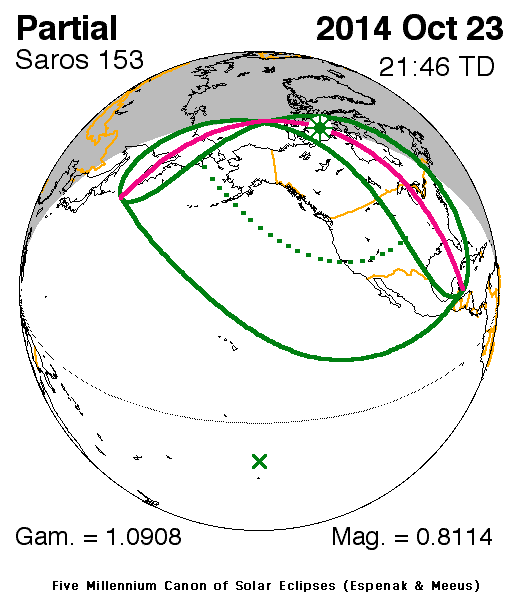
Partial Solar Eclipse of October 23
The final event of 2014 occurs at the Moon's ascending node in southern
Virgo.
Although it is only a partial solar eclipse, it is of particular
interest because the event is widely visible from Canada and the USA (Figure 4).
The penumbral shadow first touches Earth's surface near the Kamchatka
Peninsula in eastern Siberia at 19:37:33 UT.
As the shadow travels east, much of North America will be treated to a
partial eclipse.
The eclipse magnitude from cities like Vancouver (0.658), San Francisco
(0.504), Denver (0.556), and Toronto (0.443) will surely attract the
media's attention.
Greatest eclipse occurs at 21:44:31 UT in Canada's Nunavut Territory
near Prince of Wales Island where the eclipse in the horizon will have a
magnitude of 0.811.
At that time, the axis of the Moon's shadow will pass about 675 km above
Earth's surface.
A sunset eclipse will be visible from the eastern half of the USA and
Canada (except for the far northeast).
The partial eclipse ends when the penumbra leaves Earth at 23:51:40 UT.
Local circumstances and eclipse times for a number of cities in Canada and Mexico are listed in Table 4, and for the USA in Table 5.
All times are in Local Daylight Time.
The Sun's altitude and azimuth, the eclipse magnitude and eclipse obscuration are all given at the instant of maximum eclipse.
When the eclipse is in progress at sunset, this information is indicated by '- s'.
The NASA JavaScript Solar Eclipse Explorer is an interactive web page
that can quickly calculate the local circumstances of the eclipse from
any geographic location not included in Tables 4 and 5:
Javascript Solar Eclipse Explorer:
eclipse.gsfc.nasa.gov/JSEX/JSEX-index.html
This is the 9th eclipse of Saros 153 (Espenak and Meeus, 2006).
The series began on 1870 Jul 28 with a string of 13 partial eclipses.
The first of 49 annular eclipses begins on 2104 Dec 17.
The series ends with a set of 8 partial eclipses the last of which occurs on 3114 Aug 22.
In all, Saros 153 produces 70 solar eclipses in the sequence of 13 partial, 49 annular, and 8 partial eclipses.
Complete details for the series can be found at:
Lunar Eclipse Tetrads
The lunar eclipses of 2014 are the first of four consecutive total lunar
eclipses - a series known as a tetrad.
During the 5000-year period from -1999 to +3000, there are 4378
penumbral eclipses (36.3%), 4207 partial lunar eclipses (34.9%) and 3479
total lunar eclipses (28.8%).
Approximately 16.3% (568) of all total eclipses belong to one of the 142
tetrads occurring over this period (Espenak and Meeus, 2009).
The mechanism causing tetrads involves the eccentricity of Earth's orbit
in conjunction with the timing of eclipse seasons (Meeus, 2004).
During the present millennium, the first eclipse of every tetrad occurs
sometime from February to July.
In later millennia, the first eclipse date gradually falls later in the
year because of precession.
Italian astronomer Giovanni Schiaparelli first pointed out that the
frequency of tetrads is variable over time.
He noticed that tetrads were relatively plentiful during one 300-year
interval, while none occurred during the next 300 years.
For example, there are no tetrads from 1582 to 1908, but 17 tetrads
occur during the following 2 and 1/2 centuries from 1909 to 2156.
The ~565-year period of the tetrad "seasons" is tied to the slowly
decreasing eccentricity of Earth's orbit.
Consequently, the tetrad period is gradually decreasing (Meeus, 2004).
In the distant future when Earth's eccentricity is 0, tetrads will no
longer be possible.
The umbral magnitudes of the total eclipses making up a tetrad are all relatively small.
For the 300-year period 1901 to 2200, the largest umbral magnitude of a tetrad eclipse is 1.4251 on 1949 Apr 13.
For comparison, some other total eclipses during this period are much deeper.
Two examples are the total eclipses of 2000 Jul 16 and 2029 Jun 26 with umbral magnitudes of 1.7684 and 1.8436, respectively.
Table 6 gives the dates of each eclipse in the 8 tetrads occurring during the 21st century.
The tetrad prior to 2014-15 was in 2003-04 while the next group is nearly 20 years later in 2032-33.
Eclipse Altitudes and Azimuths
The altitude a and azimuth A of the Sun or Moon during an eclipse depend on the time and the observer's geographic coordinates.
They are calculated as follows:
h = 15 (GST + UT - α ) + λ
a = arcsin [sin δ sin φ + cos δ cos h cos φ]
A = arctan [-(cos δ sin h)/(sin δ cos φ - cos δ cos h sin φ)]

where

h = hour angle of Sun or Moon
a = altitude
A = azimuth
GST = Greenwich Sidereal Time at 0:00 UT
UT = Universal Time
α = right ascension of Sun or Moon
δ = declination of Sun or Moon
λ = observer's longitude (east +, west -)
φ = observer's latitude (north +, south -)
During the eclipses of 2014, the values for GST and the geocentric Right Ascension and Declination
of the Sun or the Moon (at greatest eclipse) are as follows:
Eclipse              Date           GST         α          δ

Total Lunar       2014 Apr 15     13.560     13.556     -10.050
Annular Solar     2014 Apr 29     14.475      2.431      14.448
Total Lunar       2014 Oct 08      1.133      0.919       6.307
Partial Solar     2014 Oct 23      2.148     13.887     -11.613
Two web based tools that can also be used to calculate the local
circumstances for all solar and lunar eclipses visible from any
location.
They are the Javascript Solar Eclipse Explorer and the Javascript Lunar Eclipse Explorer.
The URLs for these tools are:
Javascript Solar Eclipse Explorer:
eclipse.gsfc.nasa.gov/JSEX/JSEX-index.html
Javascript Lunar Eclipse Explorer:
eclipse.gsfc.nasa.gov/JLEX/JLEX-index.html
Eclipses During 2015
In 2015, there are two solar eclipses and two total lunar eclipses:
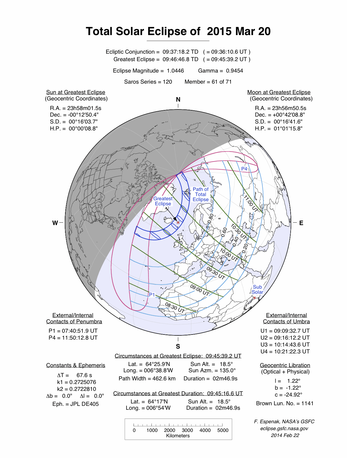
- 2015 Mar 20: Total Solar Eclipse
- 2015 Apr 04: Total Lunar Eclipse
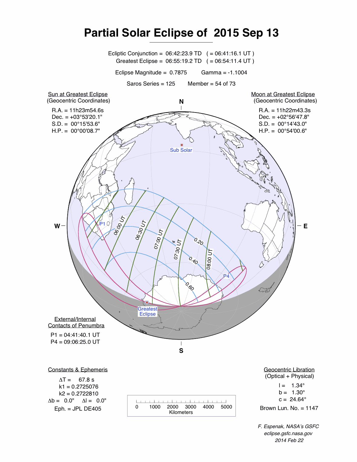
- 2015 Sep 13: Partial Solar Eclipse
- 2015 Sep 28: Total Lunar Eclipse
A full report on eclipses during 2015 will be published in Observer's Handbook: 2015.
Eclipse Web Sites
The NASA Eclipse Web Site features predictions and maps for all solar
and lunar eclipses throughout the 21st century, with special emphasis on
upcoming eclipses.
The World Atlas of Solar Eclipses provides maps of all central eclipse paths from 2000 BCE to 3000 CE.
The entire Five Millennium Canon of Solar Eclipses (Espenak and Meeus, 2006) and Five Millennium Canon of Lunar Eclipses (Espenak and Meeus, 2009a) can be downloaded in PDF format and all figures are also available online as individual GIFs.
On-line versions of the entire Five Millennium Catalog of Solar Eclipses (Espenak and Meeus, 2009c)
and Five Millennium Catalog of Lunar Eclipses (Espenak and Meeus, 2009b) list details for every solar and lunar eclipse over the same 5000-year period.
The NASA Eclipse Web Site is located at:
Detailed information on solar and lunar eclipse photography, and tips on eclipse observing and eye safety may be found at:
Acknowledgments
All eclipse predictions were generated on an Apple Power Mac G4 computer
using algorithms developed from the Explanatory Supplement [1974] with
additional algorithms from Meeus, Grosjean, and Vanderleen [1966].
The solar coordinates used in the eclipse predictions are based on
VSOP87 [P. Bretagnon and G. Francou, 1988].
The lunar coordinates are based on ELP-2000/82 [M. Chapront-Touzé and J.
Chapront, 1983].
For lunar eclipses, the diameter of the umbral and penumbral shadows
were calculated using Danjon's rule of enlarging Earth's radius by 1/85
to compensate for the opacity of the terrestrial atmosphere; corrections
for the effects of oblateness have also been included.
Text and table composition was done on a Macintosh using Microsoft Word.
Additional figure annotation was performed with Claris MacDraw Pro.
All calculations, diagrams, tables, and opinions presented in this paper
are those of the author, and he assumes full responsibility for their
accuracy.
Footnotes
[1]
The instant of greatest eclipse for lunar eclipses occurs when the
distance between the Moon's shadow axis and Earth's geocentre reaches a
minimum.
[2] Umbral eclipse magnitude is defined as the fraction of the Moon's diameter occulted by the umbral shadow.
[3]
The Saros is a period of 6,585.3 days (18 years 11 days 8 hours) in
which eclipses (both solar and lunar) repeat. The geometry isn't exact
but close enough for a Saros series to last 12 or more centuries.
[4]
The instant of greatest eclipse for solar eclipses occurs when the
distance between the Moon's shadow axis and Earth's geocentre reaches a
minimum.
[5]
Eclipse magnitude for solar eclipses is defined as the fraction of the Sun's diameter occulted by the Moon.
[6]
Eclipse obscuration is defined as the fraction of the Sun's area occulted by the Moon.
References
Bretagnon P., Francou G., "Planetary Theories in rectangular and
spherical variables: VSOP87 solution", Astron. and Astrophys.,
vol. 202, no. 309 (1988).
Chapront-Touzé, M and Chapront, J., "The Lunar Ephemeris ELP 2000," Astron. and Astrophys., vol. 124, no. 1, pp 50-62 (1983).
Chauvenet, W., Manual of Spherical and Practical Astronomy, Vol.1, 1891 (Dover edition 1961).
Danjon, A., "Les éclipses de Lune par la pénombre
en 1951," L'Astronomie, 65, 51-53 (Feb. 1951).
Espenak, F., Fifty Year Canon of Solar Eclipses: 1986–2035, Sky Publishing Corp., Cambridge, MA, 1988.
Espenak, F., Fifty Year Canon of Lunar Eclipses: 1986–2035, Sky Publishing Corp., Cambridge, MA, 1989.
Espenak, F., and Meeus, J., Five Millennium Canon of Solar Eclipses: –1999 to +3000 (2000 BCE to 3000 CE), NASA TP–2006-214141, Goddard Space Flight Center, Greenbelt, MD, 2006.
Espenak, F., and Meeus, J., Five Millennium Canon of Lunar Eclipses: –1999 to +3000 (2000 BCE to 3000 CE), NASA TP–2009-214172, Goddard Space Flight Center, Greenbelt, MD, 2009a.
Espenak, F., and Meeus, J., Five Millennium Catalog of Lunar Eclipses: –1999 to +3000 (2000 BCE to 3000 CE), NASA TP–2009-214173, Goddard Space Flight Center, Greenbelt, MD, 2009b.
Espenak, F., and Meeus, J., Five Millennium Catalog of Solar Eclipses: –1999 to +3000 (2000 BCE to 3000 CE), NASA TP–2009-214174, Goddard Space Flight Center, Greenbelt, MD, 2009c.
Explanatory Supplement to the Astronomical Ephemeris and the American Ephemeris and Nautical Almanac, Her Majesty's Nautical Almanac Office, London, 1974.
Littmann, M., Espenak, F., & Willcox, K., Totality—Eclipses of the Sun, 3rd Ed., Oxford University Press, New York, 2008.
Meeus, J., Mathematical Astronomy Morsels III, Ch. 21, Willmann-Bell, Richmond, 2004.
Meeus, J., Grosjean, C.C., & Vanderleen, W., Canon of Solar Eclipses, Pergamon Press, New York, 1966.
Meeus, J. & Mucke, H., Canon of Lunar Eclipses: -2002 to +2526, Astronomisches Buro, Wien, 1979.
April 10, 2014
Hydraulic Fracturing: The Process
What Is Hydraulic Fracturing?
Contrary to many media reports, hydraulic fracturing is not a “drilling process.” Hydraulic fracturing is used after the drilled hole is completed. Put simply, hydraulic fracturing is the use of fluid and material to create or restore small fractures in a formation in order to stimulate production from new and existing oil and gas wells. This creates paths that increase the rate at which fluids can be produced from the reservoir formations, in some cases by many hundreds of percent.
The process includes steps to protect water supplies. To ensure that neither the fluid that will eventually be pumped through the well, nor the oil or gas that will eventually be collected, enters the water supply, steel surface or intermediate casings are inserted into the well to depths of between 1,000 and 4,000 feet. The space between these casing “strings” and the drilled hole (wellbore), called the annulus, is filled with cement. Once the cement has set, then the drilling continues from the bottom of the surface or intermediate cemented steel casing to the next depth. This process is repeated, using smaller steel casing each time, until the oil and gas-bearing reservoir is reached (generally 6,000 to 10,000 ft). The diagram shown below is a generalization of a typical Eagle Ford Shale gas well in south central Texas. A more detailed look at casing and its role in groundwater protection is available HERE.

With these and other precautions taken, high volumes of fracturing fluids are pumped deep into the well at pressures sufficient to create or restore the small fractures in the reservoir rock needed to make production possible.
What's in Hydraulic Fracturing Fluid?
Water and sand make up 98 to 99.5 percent of the fluid used in hydraulic fracturing. In addition, chemical additives are used. The exact formulation varies depending on the well. To view a chart of the chemicals most commonly used in hydraulic fracturing and for a more detailed discussion of this question, click HERE.
Why is Hydraulic Fracturing Used?
Experts believe 60 to 80 percent of all wells drilled in the United States in the next ten years will require hydraulic fracturing to remain operating. Fracturing allows for extended production in older oil and natural gas fields. It also allows for the recovery of oil and natural gas from formations that geologists once believed were impossible to produce, such as tight shale formations in the areas shown on the map below. Hydraulic fracturing is also used to extend the life of older wells in mature oil and gas fields.

How is Hydraulic Fracturing Done?*
The placement of hydraulic fracturing treatments underground is sequenced to meet the particular needs of the formation. The sequence noted below from a Marcellus Shale in Pennsylvania is just one example. Each oil and gas zone is different and requires a hydraulic fracturing design tailored to the particular conditions of the formation. Therefore, while the process remains essentially the same, the sequence may change depending upon unique local conditions. It is important to note that not all of the additives are used in every hydraulically fractured well; the exact “blend” and proportions of additives will vary based on the site-specific depth, thickness and other characteristics of the target formation.
1. An acid stage, consisting of several thousand gallons of water mixed with a dilute acid such as hydrochloric or muriatic acid: This serves to clear cement debris in the wellbore and provide an open conduit for other frac fluids by dissolving carbonate minerals and opening fractures near the wellbore.
2. A pad stage, consisting of approximately 100,000 gallons of slickwater without proppant material: The slickwater pad stage fills the wellbore with the slickwater solution (described below), opens the formation and helps to facilitate the flow and placement of proppant material.
3. A prop sequence stage, which may consist of several substages of water combined with proppant material (consisting of a fine mesh sand or ceramic material, intended to keep open, or “prop” the fractures created and/or enhanced during the fracturing operation after the pressure is reduced): This stage may collectively use several hundred thousand gallons of water. Proppant material may vary from a finer particle size to a coarser particle size throughout this sequence.
4. A flushing stage, consisting of a volume of fresh water sufficient to flush the excess proppant from the wellbore.
Other additives commonly used in the fracturing solution employed in Marcellus wells include:
• A dilute acid solution, as described in the first stage, used during the initial fracturing sequence. This cleans out cement and debris around the perforations to facilitate the subsequent slickwater solutions employed in fracturing the formation.
• A biocide or disinfectant, used to prevent the growth of bacteria in the well that may interfere with the fracturingoperation: Biocides typically consist of bromine-based solutions or glutaraldehyde.
• A scale inhibitor, such as ethylene glycol, used to control the precipitation of certain carbonate and sulfate minerals
• Iron control/stabilizing agents such as citric acid or hydrochloric acid, used to inhibit precipitation of iron compounds by keeping them in a soluble form
• Friction reducing agents, also described above, such as potassium chloride or polyacrylamide-based compounds, used to reduce tubular friction and subsequently reduce the pressure needed to pump fluid into the wellbore: The additives may reduce tubular friction by 50 to 60%. These friction-reducing compounds represent the “slickwater” component of the fracing solution.
• Corrosion inhibitors, such as N,n-dimethyl formamide, and oxygen scavengers, such as ammonium bisulfite, are used to prevent degradation of the steel well casing.
• Gelling agents, such as guar gum, may be used in small amounts to thicken the water-based solution to help transport the proppant material.
• Occasionally, a cross-linking agent will be used to enhance the characteristics and ability of the gelling agent to transport the proppant material. These compounds may contain boric acid or ethylene glycol. When cross-linking additives are added, a breaker solution is commonly added later in the frac stage to cause the enhanced gelling agent to break down into a simpler fluid so it can be readily removed from the wellbore without carrying back the sand/ proppant material.
Fractures: Their orientation and length
Certain predictable characteristics or physical properties regarding the path of least resistance have been recognized since hydraulic fracturing was first conducted in the oilfield in 1947. These properties are discussed below:
Fracture orientation
Hydraulic fractures are formed in the direction perpendicular to the least stress. Based on experience, horizontal fractures will occur at depths less than approximately 2000 ft. because the Earth’s overburden at these depths provides the least principal stress. If pressure is applied to the center of a formation under these relatively shallow conditions, the fracture is most likely to occur in the horizontal plane, because it will be easier to part the rock in this direction than in any other. In general, therefore, these fractures are parallel to the bedding plane of the formation.
As depth increases beyond approximately 2000 ft., overburden stress increases by approximately 1 psi/ft., making the overburden stress the dominant stress This means the horizontal confining stress is now the least principal stress. Since hydraulically induced fractures are formed in the direction perpendicular to the least stress, the resulting fracture at depths greater than approximately 2000 ft. will be oriented in the vertical direction.
In the case where a fracture might cross over a boundary where the principal stress direction changes, the fracture would attempt to reorient itself perpendicular to the direction of least stress. Therefore, if a fracture propagated from deeper to shallower formations it would reorient itself from a vertical to a horizontal pathway and spread sideways along the bedding planes of the rock strata.
Fracture length/ height
The extent that a created fracture will propagate is controlled by the upper confining zone or formation, and the volume, rate, and pressure of the fluid that is pumped. The confining zone will limit the vertical growth of a fracture because it either possesses sufficient strength or elasticity to contain the pressure of the injected fluids or an insufficient volume of fluid has been pumped.. This is important because the greater the distance between the fractured formation and the USDW, the more likely it will be that multiple formations possessing the qualities necessary to impede the fracture will occur. However, while it should be noted that the length of a fracture can also be influenced by natural fractures or faults as shown in a study that included microseismic analysis of fracture jobs conducted on three wells in Texas, natural attenuation of the fracture will occur over relatively short distances due to the limited volume of fluid being pumped and dispersion of the pumping pressure regardless of intersecting migratory pathways.
Extensive mapping of hydraulic fracture geometry has been performed in unconventional North American shale reservoirs since 2001. The microseismic and tiltmeter technologies used to monitor the treatments are well established, and are also widely used for nonoil field (sic) applications such as earthquake monitoring, volcano monitoring, civil engineering applications, carbon capture and waste disposal. Figures 1 and 2 are plots of data collected on thousands of hydraulic fracturing treatments in the Barnett Shale in the Fort Worth Basin in Texas and in the Marcellus Shale in the Appalachian Basin.

Figure 1. Barnett Shale
More fracs have been mapped in the Barnett than any other reservoir. The graph illustrates the fracture top and bottom for all mapped treatments performed in the Barnett since 2001. The depths are in true vertical depth. Perforation depths are illustrated by the red-colored band for each stage, with the mapped fracture tops and bottoms illustrated by colored curves corresponding to the counties where they took place.
The deepest water wells in each of the counties where Barnett Shale fracs have been mapped, according to United States Geological Survey (http://nwis.waterdata.usgs.gov/nwis ‡), are illustrated by the dark blue shaded bars at the top of Figure 1. As can be seen, the largest directly measured upward growth of all of these mapped fractures still places the fracture tops several thousands of feet below the deepest known aquifer level in each county.

Figure 2 Marcellus Shale
The Marcellus data show a similarly large distance between the top of the tallest frac and the location of the deepest drinking water aquifers as reported in USGS data (dark blue shaded bars at the top of Figure 2). Because it is a newer play with fewer mapped frac stages at this point and encompasses several states, the data set is not as comprehensive as that from the Barnett. However, it is no less compelling in providing evidence of a very good physical separation between hydraulic fracture tops and water aquifers.
Almost 400 separate frac stages are shown, color coded by state. As can be seen, the fractures do grow upward quite a bit taller than in the Barnett, but the shallowest fracture tops are still ±4,500 feet, almost one mile below the surface and thousands of feet below the aquifers in those counties.
The results from our extensive fracture mapping database show that hydraulic fractures are better confined vertically (and are also longer and narrower) than conventional wisdom or models predict. Even in areas with the largest measured vertical fracture growth, such as the Marcellus, the tops of the hydraulic fractures are still thousands of feet below the deepest aquifers suitable for drinking water. The data from these two shale reservoirs clearly show the huge distances separating the fracs from the nearest aquifers at their closest points of approach, conclusively demonstrating that hydraulic fractures are not growing into groundwater supplies, and therefore, cannot contaminate them.”
* Pennsylvania Department of Environmental Protection
“Hydraulic Fracturing Overview.” 07/20/2010.
Contrary to many media reports, hydraulic fracturing is not a “drilling process.” Hydraulic fracturing is used after the drilled hole is completed. Put simply, hydraulic fracturing is the use of fluid and material to create or restore small fractures in a formation in order to stimulate production from new and existing oil and gas wells. This creates paths that increase the rate at which fluids can be produced from the reservoir formations, in some cases by many hundreds of percent.
The process includes steps to protect water supplies. To ensure that neither the fluid that will eventually be pumped through the well, nor the oil or gas that will eventually be collected, enters the water supply, steel surface or intermediate casings are inserted into the well to depths of between 1,000 and 4,000 feet. The space between these casing “strings” and the drilled hole (wellbore), called the annulus, is filled with cement. Once the cement has set, then the drilling continues from the bottom of the surface or intermediate cemented steel casing to the next depth. This process is repeated, using smaller steel casing each time, until the oil and gas-bearing reservoir is reached (generally 6,000 to 10,000 ft). The diagram shown below is a generalization of a typical Eagle Ford Shale gas well in south central Texas. A more detailed look at casing and its role in groundwater protection is available HERE.
With these and other precautions taken, high volumes of fracturing fluids are pumped deep into the well at pressures sufficient to create or restore the small fractures in the reservoir rock needed to make production possible.
What's in Hydraulic Fracturing Fluid?
Water and sand make up 98 to 99.5 percent of the fluid used in hydraulic fracturing. In addition, chemical additives are used. The exact formulation varies depending on the well. To view a chart of the chemicals most commonly used in hydraulic fracturing and for a more detailed discussion of this question, click HERE.
Why is Hydraulic Fracturing Used?
Experts believe 60 to 80 percent of all wells drilled in the United States in the next ten years will require hydraulic fracturing to remain operating. Fracturing allows for extended production in older oil and natural gas fields. It also allows for the recovery of oil and natural gas from formations that geologists once believed were impossible to produce, such as tight shale formations in the areas shown on the map below. Hydraulic fracturing is also used to extend the life of older wells in mature oil and gas fields.
How is Hydraulic Fracturing Done?*
The placement of hydraulic fracturing treatments underground is sequenced to meet the particular needs of the formation. The sequence noted below from a Marcellus Shale in Pennsylvania is just one example. Each oil and gas zone is different and requires a hydraulic fracturing design tailored to the particular conditions of the formation. Therefore, while the process remains essentially the same, the sequence may change depending upon unique local conditions. It is important to note that not all of the additives are used in every hydraulically fractured well; the exact “blend” and proportions of additives will vary based on the site-specific depth, thickness and other characteristics of the target formation.
1. An acid stage, consisting of several thousand gallons of water mixed with a dilute acid such as hydrochloric or muriatic acid: This serves to clear cement debris in the wellbore and provide an open conduit for other frac fluids by dissolving carbonate minerals and opening fractures near the wellbore.
2. A pad stage, consisting of approximately 100,000 gallons of slickwater without proppant material: The slickwater pad stage fills the wellbore with the slickwater solution (described below), opens the formation and helps to facilitate the flow and placement of proppant material.
3. A prop sequence stage, which may consist of several substages of water combined with proppant material (consisting of a fine mesh sand or ceramic material, intended to keep open, or “prop” the fractures created and/or enhanced during the fracturing operation after the pressure is reduced): This stage may collectively use several hundred thousand gallons of water. Proppant material may vary from a finer particle size to a coarser particle size throughout this sequence.
4. A flushing stage, consisting of a volume of fresh water sufficient to flush the excess proppant from the wellbore.
Other additives commonly used in the fracturing solution employed in Marcellus wells include:
• A dilute acid solution, as described in the first stage, used during the initial fracturing sequence. This cleans out cement and debris around the perforations to facilitate the subsequent slickwater solutions employed in fracturing the formation.
• A biocide or disinfectant, used to prevent the growth of bacteria in the well that may interfere with the fracturingoperation: Biocides typically consist of bromine-based solutions or glutaraldehyde.
• A scale inhibitor, such as ethylene glycol, used to control the precipitation of certain carbonate and sulfate minerals
• Iron control/stabilizing agents such as citric acid or hydrochloric acid, used to inhibit precipitation of iron compounds by keeping them in a soluble form
• Friction reducing agents, also described above, such as potassium chloride or polyacrylamide-based compounds, used to reduce tubular friction and subsequently reduce the pressure needed to pump fluid into the wellbore: The additives may reduce tubular friction by 50 to 60%. These friction-reducing compounds represent the “slickwater” component of the fracing solution.
• Corrosion inhibitors, such as N,n-dimethyl formamide, and oxygen scavengers, such as ammonium bisulfite, are used to prevent degradation of the steel well casing.
• Gelling agents, such as guar gum, may be used in small amounts to thicken the water-based solution to help transport the proppant material.
• Occasionally, a cross-linking agent will be used to enhance the characteristics and ability of the gelling agent to transport the proppant material. These compounds may contain boric acid or ethylene glycol. When cross-linking additives are added, a breaker solution is commonly added later in the frac stage to cause the enhanced gelling agent to break down into a simpler fluid so it can be readily removed from the wellbore without carrying back the sand/ proppant material.
Fractures: Their orientation and length
Certain predictable characteristics or physical properties regarding the path of least resistance have been recognized since hydraulic fracturing was first conducted in the oilfield in 1947. These properties are discussed below:
Fracture orientation
Hydraulic fractures are formed in the direction perpendicular to the least stress. Based on experience, horizontal fractures will occur at depths less than approximately 2000 ft. because the Earth’s overburden at these depths provides the least principal stress. If pressure is applied to the center of a formation under these relatively shallow conditions, the fracture is most likely to occur in the horizontal plane, because it will be easier to part the rock in this direction than in any other. In general, therefore, these fractures are parallel to the bedding plane of the formation.
As depth increases beyond approximately 2000 ft., overburden stress increases by approximately 1 psi/ft., making the overburden stress the dominant stress This means the horizontal confining stress is now the least principal stress. Since hydraulically induced fractures are formed in the direction perpendicular to the least stress, the resulting fracture at depths greater than approximately 2000 ft. will be oriented in the vertical direction.
In the case where a fracture might cross over a boundary where the principal stress direction changes, the fracture would attempt to reorient itself perpendicular to the direction of least stress. Therefore, if a fracture propagated from deeper to shallower formations it would reorient itself from a vertical to a horizontal pathway and spread sideways along the bedding planes of the rock strata.
Fracture length/ height
The extent that a created fracture will propagate is controlled by the upper confining zone or formation, and the volume, rate, and pressure of the fluid that is pumped. The confining zone will limit the vertical growth of a fracture because it either possesses sufficient strength or elasticity to contain the pressure of the injected fluids or an insufficient volume of fluid has been pumped.. This is important because the greater the distance between the fractured formation and the USDW, the more likely it will be that multiple formations possessing the qualities necessary to impede the fracture will occur. However, while it should be noted that the length of a fracture can also be influenced by natural fractures or faults as shown in a study that included microseismic analysis of fracture jobs conducted on three wells in Texas, natural attenuation of the fracture will occur over relatively short distances due to the limited volume of fluid being pumped and dispersion of the pumping pressure regardless of intersecting migratory pathways.
The following text and
graphs are excerpts from an article written by Kevin Fisher of Pinnacle,
a Halliburton Company for the July 2010 edition of the American Oil and
Gas Reporter.
“The concerns around groundwater contamination raised by Congress are
primarily centered on one fundamental question: Are the created fractures
contained within the target formation so that they do not contact underground
sources of drinking water? In response to that key concern, this article
presents the first look at actual field data based on direct measurements
acquired while fracture mapping more than 15,000 frac jobs during the past
decade.Extensive mapping of hydraulic fracture geometry has been performed in unconventional North American shale reservoirs since 2001. The microseismic and tiltmeter technologies used to monitor the treatments are well established, and are also widely used for nonoil field (sic) applications such as earthquake monitoring, volcano monitoring, civil engineering applications, carbon capture and waste disposal. Figures 1 and 2 are plots of data collected on thousands of hydraulic fracturing treatments in the Barnett Shale in the Fort Worth Basin in Texas and in the Marcellus Shale in the Appalachian Basin.
Figure 1. Barnett Shale
More fracs have been mapped in the Barnett than any other reservoir. The graph illustrates the fracture top and bottom for all mapped treatments performed in the Barnett since 2001. The depths are in true vertical depth. Perforation depths are illustrated by the red-colored band for each stage, with the mapped fracture tops and bottoms illustrated by colored curves corresponding to the counties where they took place.
The deepest water wells in each of the counties where Barnett Shale fracs have been mapped, according to United States Geological Survey (http://nwis.waterdata.usgs.gov/nwis ‡), are illustrated by the dark blue shaded bars at the top of Figure 1. As can be seen, the largest directly measured upward growth of all of these mapped fractures still places the fracture tops several thousands of feet below the deepest known aquifer level in each county.
Figure 2 Marcellus Shale
The Marcellus data show a similarly large distance between the top of the tallest frac and the location of the deepest drinking water aquifers as reported in USGS data (dark blue shaded bars at the top of Figure 2). Because it is a newer play with fewer mapped frac stages at this point and encompasses several states, the data set is not as comprehensive as that from the Barnett. However, it is no less compelling in providing evidence of a very good physical separation between hydraulic fracture tops and water aquifers.
Almost 400 separate frac stages are shown, color coded by state. As can be seen, the fractures do grow upward quite a bit taller than in the Barnett, but the shallowest fracture tops are still ±4,500 feet, almost one mile below the surface and thousands of feet below the aquifers in those counties.
The results from our extensive fracture mapping database show that hydraulic fractures are better confined vertically (and are also longer and narrower) than conventional wisdom or models predict. Even in areas with the largest measured vertical fracture growth, such as the Marcellus, the tops of the hydraulic fractures are still thousands of feet below the deepest aquifers suitable for drinking water. The data from these two shale reservoirs clearly show the huge distances separating the fracs from the nearest aquifers at their closest points of approach, conclusively demonstrating that hydraulic fractures are not growing into groundwater supplies, and therefore, cannot contaminate them.”
* Pennsylvania Department of Environmental Protection
“Hydraulic Fracturing Overview.” 07/20/2010.